
The Tar Story
Sooner or later every summer, the same question shows up on Santa Barbara’s beaches: is the tar on my feet from a spill, or is it just the ocean doing what it has always done? Both sources are real, and weathering can make them chemically difficult to separate. The records below explain what researchers have measured and where those records leave questions open.
The seeps were here first
Just offshore of Coal Oil Point, at the western edge of UC Santa Barbara, sits one of the most active natural oil and gas seep fields in the world. The reservoir rock is the Monterey Formation, an organic-rich Miocene unit that underlies much of the Santa Barbara Channel; oil and gas migrate up faults and fractures and vent through the seafloor into open water. A USGS survey done with the Minerals Management Service and Santa Barbara County’s Energy Division mapped seepage from Point Conception east to Coal Oil Point and found that it occurs, by and large, inside the three-mile limit of California state waters (USGS Open-File Report 2009-1225, Chapter 1).
How much oil? Less precisely than most retellings suggest. The published estimates for this one field, as compiled in that report, are:
- 50 to 70 barrels a day from the shallow seeps directly south of Coal Oil Point, measured in 1970 by inverted jug capture and aerial slick photography over roughly 3,000 square meters of seafloor, not the whole field, with the authors noting the flux “can range from 10 to 100 barrels per day easily” (Allen and others, 1970).
- 25 to 400 barrels a day for the whole field, which Fischer (1977) put at roughly 60 percent of the total flux for the entire Santa Barbara Channel.
- About 150 to 170 barrels a day, roughly 23,800 to 27,000 liters, or about 6,300 to 7,100 gallons, for the field including the shallow seeps. Read the provenance carefully, because this one is a composite rather than a single measurement: USGS OFR 2009-1225 (page 17) adds Allen’s shallow-seep survey to the deeper-seep estimate of Hornafius, Quigley and Luyendyk (1999), who derived 100 barrels a day (1.6 × 10⁴ liters) for the field from a 50 kHz sonar gas survey combined with a measured oil-to-gas ratio.
That last line matters, because the figure repeated almost everywhere, including in NOAA’s own 2021 incident record for a sheen near Platform Holly (“an estimated 6,500-7,000 gallons/day of oil”), is that composite, rounded. It rests on real measurements, but it splices two surveys from 1970 and 1999, it is decades old, and the published range for the field spans more than an order of magnitude.
Gas flux is a separate measurement. Hornafius, Quigley and Luyendyk’s 1999 paper reports about 170,000 cubic meters of hydrocarbon gas per day (1.7 ± 0.3 × 10⁵ m³ d⁻¹) for an 18 square kilometer field, including gas captured by a subsea containment device. That is not a present-day atmospheric-emissions measurement. The USGS report also discusses a smaller-area atmospheric flux; values with different footprints, capture accounting and pathways should not be compared as if they measured the same thing.
For scale, the same USGS report puts about 1,300,000 tons of oil entering the world’s oceans annually during the 1990s, of which natural seeps contributed roughly 600,000 tons; California’s marine seeps account for something like 20,000 tons of North America’s estimated 160,000.
None of this is new. European explorers between the 16th and 18th centuries recorded petroleum on the sea surface here and its use by the Chumash, who used asphalt gathered on the Coal Oil Point beaches to caulk their canoes. Asphalt mining flourished in Santa Barbara County in the mid-1800s, and its product paved the first streets of San Francisco and Santa Barbara (Galloway, 1998, as cited in USGS OFR 2009-1225).
Seepage is not a steady drip
It is tempting to treat the seeps as a constant background you can subtract. The record does not support that.
- Individual seeps differ enormously. The shallowest vents, in 3 to 12 meters of water, release gas with only trace hydrocarbons; deeper vents release gas and non-trace oil. Some seeps produce hundreds of surfacing oil droplets in half an hour and a large slick; others of comparable gas flux produce very little oil. Some have built exposed asphalt mounds on the seafloor. Seepage at a given vent can be intermittent, and many vents have never been visited (USGS OFR 2009-1225, Chapter 1).
- The field has changed on decadal scales. Fischer and Stevenson (1973) reported a significant decrease in seepage area near Platform Holly between 1946 and 1973. Comparing 1973 and 1995 data, Quigley and others (1999) documented a decrease in the area and number of seeps within 1.5 km of Platform Holly and attributed it to oil production drawing down reservoir pressure. That is an attribution from correlated observations across two surveys, not a controlled result, and it cuts against the intuition that drilling can only add oil to the water.
- Tides modulate it. The USGS work found natural seepage is affected by the spring/neap tidal cycle. It also found that the link from that modulation to what lands on the sand is unclear.
One published beach-scale monitoring effort ran from 2001 to 2003. USGS and Santa Barbara County conducted monthly and quarterly tarball transects on ten county beaches, weighing and counting tar within two meters of randomly placed transect lines. Tar accumulated faster, or persisted longer, on all beaches in summer and fall. Coal Oil Point beach received the highest number of tarballs; the northern county beaches collected the largest and heaviest ones. The report’s explanation is explicitly speculative: prevailing winds and currents plus calmer summer wave conditions, versus winter storms that strip sand and break up oil before it can cure into tar. It calls for longer monitoring and a robust statistical analysis.
That 2001-2003 effort is, as far as we have been able to find, the last published multi-beach tar time series for this coast. The state is now moving to fill part of the gap: the California State Lands Commission has authorized a consultant to conduct seep studies in the Santa Barbara Channel, budgeted at $600,000 and scheduled for February 2026 through January 2029, intended to inventory offshore natural tar, oil and gas seeps and determine locations, rates and fingerprints in state waters (2025 SB 44 progress report, pages 12-13).
Then people drilled into the same rock
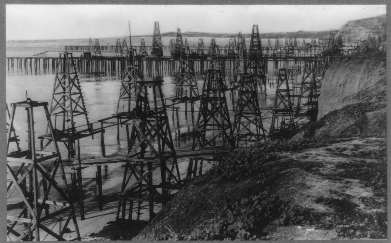
“California, Santa Barbara. Pumping oil out of the Pacific Ocean at Summerland, California,” dated by the Library of Congress to about 1920. Library of Congress Prints and Photographs Division; the item record carries the rights advisory “No known restrictions on publication.” LOC item 2012647900.
Summerland sits about five miles east of the city of Santa Barbara, and the State Lands Commission calls the wells that once stood in its surf “California’s first offshore oil wells.” The USGS geologist Ralph Arnold, whose survey of the district was published in 1907, described how they got there: “the development in 1896 began along the beach and finally extended out toward the ocean, the wells being drilled from wharves built out over the water” (USGS Bulletin 321). Arnold put the field’s total production from 1895 to January 1, 1907 at 1,373,980 barrels, excluding 1896, for which he had no figure. Then it faded.
What it left behind is the part that still shows up on feet. The California State Lands Commission, which is responsible for these wells because no operator survives to be, describes the Summerland field this way: hundreds of wells, drilled and plugged without regulation, production ceasing in the early 1900s, and “virtually no records” of how any of it was abandoned. Its current count is 200 high-priority legacy wells that could, depending on condition, leak oil into the marine environment. Its description of what beachgoers see is the cleanest statement of the attribution problem anyone has written: “Oil leaks and sheens are regularly observed on the beach and in the water near Summerland Beach. Some oil is from natural seeps, and some is from improperly plugged and abandoned legacy wells” (Coastal Hazards and Legacy Wells program; 2025 SB 44 progress report, page 1).
Nine of those wells have now been permanently re-abandoned. The Commission counts “eight wells since the Program’s inception,” which is the SB 44 program’s own tally from 2020 onward; Becker #1, done in 2018, sits outside that count as the pilot. Its project record lists the completions this way:
| Well | Completed | Setting |
|---|---|---|
| Becker #1 | March 2018 | Surf zone, cofferdam |
| Treadwell 10 and NorthStar 815 | November 2020 | Offshore, crane barge and divers |
| Olsson 805 | July 2021 | Surf zone |
| Duquesne 910 | December 2021 | Surf zone |
| Treadwell Pier Wells 1 and 5 | September 2023 | Offshore, crane barge and divers |
| Wells A and B | February 2025 | Surf zone |
Re-abandonment is not always the end of the story, either. On October 10, 2025, oil was reported leaking in the vicinity of the Duquesne-910 well, four years after that well was plugged. Commission staff investigated a possible leak from a screw cap on the well and seepage from outside the casing; a contractor crew went out on November 6, “identified the leak source, repaired it, and restored the area.” Wells C and D at Summerland are next, with engineering and permits planned for 2026 (2025 SB 44 progress report, pages 2-3 and 12).
Becker #1 was drilled in the 1890s and sat directly in the surf zone. The Commission encapsulated it inside a driven 24-inch pipe pile and cement in a cofferdam operation completed on March 1, 2018, for about $1.2 million, and reports the remediation complete (Becker Well Re-Abandonment Summary). That is a dated remediation record, not continuous monitoring of every nearby oil source. The 2015 excavation found cement inside the casing and none outside it, allowing oil to migrate along the outside of the pipe.
West of Coal Oil Point, the Ellwood field was drilled through the 1920s and 1930s from more than sixteen oil piers reaching into shallow water; the wells at the field’s eastern and western ends were abandoned by 1971 and 1993. Offshore production in the South Ellwood field began in 1967 with Platform Holly (USGS OFR 2009-1225, Chapter 1). The State Lands Commission issued a Notice of Preparation for a Platform Holly decommissioning environmental impact report on January 22, 2026, with comments extended to March 6 (project page). This is Holly’s project status, not a statement about all Channel platforms. Abandonment work itself also requires care: in May 2019 a shoreside well abandonment at Ellwood Beach spilled one to three barrels of crude (NOAA case 9909).
January 28, 1969
The blowout happened on well A-21 under Union Oil’s Platform A, 5.5 miles southeast of Santa Barbara in the Dos Cuadras field, while drill bits were being changed. Oil, gas and mud came up the casing and onto the platform. The well itself was capped on February 7 with 13,000 barrels of heavy drilling mud, but that did not end it: oil kept venting from natural faults in the seafloor a few hundred yards from the platform, and those faults released a total of about 100,000 barrels, roughly 4.2 million gallons, through December 1969 (NOAA IncidentNews case 6206).
Capping the well did not end the release because the pathway was fractured seafloor rather than a pipe that could be valved shut. Two other details from NOAA’s record matter. A record-breaking storm just before the blowout added enormously to the volume of oiled debris that had to be collected. And on February 2, 1969, the federal National Pollution Contingency Plan, established the year before, was activated for the first time in its history. The spill’s larger role in American environmental politics, including the first Earth Day the following year, is the conventional historical account and a reasonable one; it is not something this page can source to a record, so treat it as history rather than data.
May 19, 2015
A 24-inch Plains All American pipeline, Line 901, ruptured next to Highway 101 near Refugio State Beach. Oil ran down a culvert under the freeway and into the ocean.
NOAA’s records preserve an early estimate and a later assessment; they should not be treated as contradictory final totals:
- NOAA’s day-one incident record puts the release at an estimated 500 barrels, 21,000 gallons, discharged on the inland side of the highway and then flowing to the ocean, with the resulting sheen about 3.5 nautical miles along the beach and 50 to 100 yards out (case 8934).
- NOAA’s damage-assessment case page puts the total release at over 100,000 gallons, “much of which ran down a storm drain and into a ravine under the freeway, entering the ocean” (NOAA DARRP).
If you want the underlying measurements rather than a headline, the trustees’ sampling data is public in NOAA DIVER’s Refugio Beach project.
Tar turning up far down the coast was investigated, not assumed. When oil was reported at Manhattan Beach on May 27, NOAA ran a hindcast trajectory specifically to test whether it was connected to Refugio (case 8939); the case record documents the question being asked, which is not the same as an answer.
The legal and restoration tail is long. A $22.3 million natural resource damage settlement was finalized in 2020, and the trustees’ final Damage Assessment and Restoration Plan, issued in June 2021, allocates $22 million across subtidal and fish habitat, shoreline habitat, marine mammals, birds, recreation, and implementation (NOAA DARRP, above). Some of it lands back at the seep field: the trustees allocated $16,415 to Coal Oil Point Reserve in 2023 for western snowy plover work, under which 30 abandoned eggs went to the Santa Barbara Zoo for captive rearing and 19 of the resulting chicks were released at the reserve (10-year anniversary newsletter, page 3).
Why you often cannot tell by looking
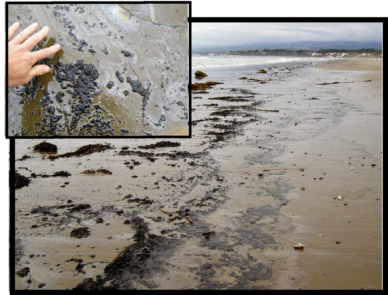
Fresh tar residue at Coal Oil Point, photographed June 10, 2003 (Figure I-4 of USGS Open-File Report 2009-1225). Note the sheen in the close-up: that is what “fresh” looks like before weathering hardens it. USGS-produced material is in the public domain.
A tar ball from a pipeline and a tar ball from a vent 40 meters down can end up looking and feeling identical. Separating them is a job for a mass spectrometer, and the USGS report above is the most comprehensive published attempt for this coastline: 388 samples of produced crude, seep oil and tarballs described by biomarker ratios and stable carbon isotope values, assembled into a chemometric decision tree, then used to classify 288 more. The oils sort into three “tribes” traceable to different members of the Monterey Formation, and 13 families within them; one family alone accounts for 316 of the samples.
Here is the finding that should reset expectations. Biomarkers can sometimes identify an individual platform’s oil, but “produced platform oil samples and seep samples with sources geographically close to each other are too similar to each other, with respect to the biomarker parameters, to definitively differentiate them on that basis alone.” What actually separates the two classes is weathering state, and the reason is elegant: every produced platform oil in the sample set still contained n-alkanes and the isoprenoids pristane and phytane, while most seep oils had already been biodegraded past the loss of those compounds underground, before they ever reached the water.
Which means the clock you are racing depends on where the oil came from:
- Near Coal Oil Point and Platform A, seep oil and Platform Holly or Platform A oil are so genetically similar that they “cannot be definitively distinguished after a period of a few days of weathering.”
- Oils from the Point Conception platforms can be distinguished on chemometric fingerprinting alone.
- Oils from Platforms Harmony, Heritage and Hondo need on the order of two weeks to a month of weathering before they converge on the tar signature common along the nearby coast.
And the report prints its own limit: only 9 of 23 active platform oils, plus one inactive platform, were included, so “this model is not comprehensive, and the findings are not yet conclusive.”
You can watch that vocabulary being used correctly in the incident record. During a broad tarballing episode from Santa Monica Bay to Dana Point in the spring of 2022, NOAA recorded that most tarballs were moderately to heavily weathered and that “analysis indicates they are chemically consistent with natural seep oil” (case 10455). “Consistent with” is doing real work in that sentence, and it is not a synonym for “from.”
The reverse case is just as instructive. On August 13, 2026, NOAA logged a satellite Marine Pollution Surveillance Report for a discharge seven nautical miles southeast of Santa Barbara, rated high confidence, where “the source appears to be Platform B,” with the Coast Guard contacting the operator (case 11201). That is an instrument-based inference about a slick and a lead worth chasing. It is not a confirmed attribution, and Tarline does not present it as one.
What tar tells you about risk, and what it does not
You cannot read toxicity off the surface of a tar ball, and this site will not pretend otherwise.
The most on-point official guidance is NOAA’s: tar balls are weathered oil, “hard and crusty on the outside and soft and gooey on the inside,” warmth makes them stickier, and “occasional brief contact with a small amount of oil, while not recommended, will do no harm” for most people, though some get rashes or allergic reactions. Wash it off with soap and water; do not use gasoline, kerosene, diesel or solvents, which are a greater hazard than the tar (NOAA Office of Response and Restoration).
Weathering generally removes volatile compounds, so hardened tar is expected to release fewer volatile hydrocarbons than fresh oil. That does not establish zero inhalation risk, and appearance alone cannot measure exposure. Weathered petroleum can retain polycyclic aromatic hydrocarbons; some PAHs are carcinogenic, but the sources reviewed here do not quantify a safe dose for casual beach contact (ATSDR: PAHs, total petroleum hydrocarbons, benzene). Avoid contact and follow official guidance.
So Tarline’s number is a condition score built from what people can actually see: how much tar, what form, how sticky, and whether there is any sign of oil in the water. It is not a health advisory, not a measured exposure, and not a lab result. Official closures and postings win, every time.
Why a timestamp is worth as much as a sample
Given the chemistry above, the single most useful thing a person on a beach can contribute is not a guess about the source. It is a defensible answer to when and where, because for the oils closest to Santa Barbara the attribution window is measured in days.
A precise observation time and location let researchers compare a beach report with wind, current and swell records from the same window. Transport modeling can then test candidate pathways, with uncertainty; it cannot identify an oil source by itself. A crowd cannot replace laboratory analysis. Dated, located reports can help guide sampling and build a public multi-beach record that complements the published studies.
What is settled, what is not, and what Tarline decides
Settled, and sourced above. Coal Oil Point is one of the world’s most active seep fields, and it was seeping long before anyone drilled here. Seepage is not constant in space, time or oiliness. Summerland’s late-1890s wells were drilled from piers and abandoned without records, roughly 200 of them are still ranked high-priority for potential leakage, and nine have been permanently re-abandoned since 2018. The 1969 blowout released about 100,000 barrels through December 1969. Line 901 ruptured on May 19, 2015. Weathering destroys source-specific chemistry, and for oils originating near Coal Oil Point it does so within days.
Questions the reviewed evidence leaves open. A current, comparable field-wide oil-flux estimate; the causes of seasonal beach-tar patterns; how tidal modulation of seepage translates to stranding on sand; and how much production near Platform Holly contributed to the observed seep changes. These are limits of the records reviewed here, not claims that no later research exists. The sources also do not establish a recreational exposure threshold that Tarline could turn into a health score.
Tarline’s design judgments, which are ours and not findings. That an unattributed but well-timed observation is worth recording. That “no reports” must display as unknown rather than clean. That severity should be scored from what an observer can see, in vocabulary borrowed from NOAA’s shoreline assessment scheme, with water-column signs weighted highest because they add ingestion and whole-body contact routes. That satellite and caller-reported detections are shown as leads, labeled, and never merged into scored data. And that visible tar never implies a measured health risk.
Corrections
This revision corrects earlier claims and identifies the records behind them:
- The Coal Oil Point oil-flux figure of 6,500 to 7,000 gallons a day was credited to “NOAA researchers.” It reaches NOAA only by way of a 2021 incident narrative, and it is not a single measurement: it is a USGS composite of a 1970 shallow-seep survey and Hornafius, Quigley and Luyendyk’s 1999 deeper-seep estimate, whose own field-wide figure is 100 barrels a day. The published range for the field spans 10 to 400 barrels a day.
- The 1969 blowout was described as roughly three million gallons over a few weeks. NOAA’s case record says about 100,000 barrels, or 4.2 million gallons, through December 1969.
- Refugio 2015 was described as roughly 140,000 gallons spilled with about 100,000 reaching the ocean. The cited records did not establish those quantities. The early incident estimate and later total-release assessment are now dated and distinguished, without inventing a final ocean-entry volume.
- The Becker well was described as still leaking. The State Lands Commission permanently re-abandoned it in March 2018 and reports the remediation complete.
Living Record
2,160 incident reports along the California coast since 1990 — pulled continuously from NOAA IncidentNews, the U.S. Coast Guard National Response Center, NOAA's satellite surveillance program, and Cal Spill Watch. This count updates as new reports land; search or page through the complete record in the Incident Archive.